USCAmpgrounds.info
The most comprehensive guide to Federal, State, Provincial and Local campgrounds
The most comprehensive guide to Federal, State, Provincial and Local campgrounds
 |
 13,000
public
campgrounds- entire US and Canada 13,000
public
campgrounds- entire US and Canada Latitude/longitude
of every
campground verified
Latitude/longitude
of every
campground verifiedInteractive street/topo maps, downloadable data files for your GPS or laptop mapping software - all free |
"You have by far the best camping website in the world." Mary Cuneo, Newcastle, CA |
| -DATA TO GO- For your GPS, PHONE, TABLET or LAPTOP |
-CONTACTS-
Reservation phone numbers and web sites for all government campground agencies. |
FAQ |
|
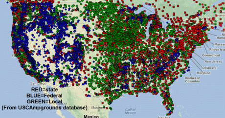
It
is all here,
on one map and at your fingertips: All 13,000 US and
Canada
(vehicle-accessible) public campgrounds, with accurate lat/lon for your
GPS
or smart phone,
campground amenities, phone numbers and web links for both the
campground itself and it's reservation system.
Includes all National Park, National Forest, State Park and
Provincial campgrounds,
all BLM, TVA and Army engineers and military-only campgrounds. Most
regional, county, city
and
utility-owned are also included.
We include only vehicle-accessible, family campgrounds with 4 or more campsites - whose existence and location we can verify. We want to be sure you find an actual family campground when you drive there. We try to tell you if you need a 4 wheel drive or high-clearance vehicle. (no backpack-in, boat-in, horse camps or group-only camps). We do include some selected "boondocks" (no facilities), (we call "dispersed") We will tell you if you need to take a ferry or if a short walk to the sites is required. We do not include privately owned campgrounds.
Click here to email us with any general question, specific campground errors or omissions you find, comment or suggestion.
Map
Usage: To
re-position map, drag or put 2 letter State abbreviation in "find" box
on map.
Zoom
in: Double click (also re-centers) or use slider in upper left of
map.
Click on campground symbol for more info - for explanation of codes,
see legend below map.
For a topo or
other map, zoom in tight and switch map type in the upper
right
corner of the map.
 : If the 4 letter name is preceeded
by a � it has a dump, if preceeded
by a - it does not. If the 4
letter name is followed by a �, it has RV
hookups (at
least electric), if - it has none. If either are missing,
it means we dont know, use one of the links to get this information.
: If the 4 letter name is preceeded
by a � it has a dump, if preceeded
by a - it does not. If the 4
letter name is followed by a �, it has RV
hookups (at
least electric), if - it has none. If either are missing,
it means we dont know, use one of the links to get this information. AMENITIES: NOTE: We do not yet have all info for all campgrounds. If there is no mention of an amenity, it does NOT mean it is not there, it means we don't have data about it (yet). Use one of the links to get the full information.
RV HOOKUPS: (Some campgrounds listed with only "E" hookups may actually have additional hookups but we don't have specific data) NH=no hookups E, WE, WES=Water Electric Sewer SANITARY DUMP: DP=dump ND=no dump MAX RV LENGTH: (may not be very accurate - call ahead if you have a long rig.) 32ft=32 feet TOILETS: FT=flush VT=vault FTVT=some FT, some VT PT=pit NT= no toilets DRINKING WATER: DW=drinking water at campground NW=no drinking water(bring your own) |
SHOWERS: SH=showers NS=no showers RESERVATIONS: RS=accepts reservations NR=no reservations Blank = unknown Reservations=no data on this (Reservation phone and web site are always listed (if we have them) so you can check about reservations) PETS: PA=pets allowed NP=no pets allowed FEE: L$=free or under $12 |
12mi SE of Woodland: The miles are a rough approximation of road miles. In mountains/canyons or near water it could be much farther.
PHONE NUMBERS : We usually provide two numbers: 1) for the campground itself 2) for reservations. For NF, we often list 2 campground numbers: District office (try this one first)/Forest office (try second) - these are offices, not at the campground, so call before 4:30 PM.
RESERVATION INFO (RES.): We list the central res. phone and web (if any) even if we say res. not accepted or res. unknown so you can check youself - these things do change.
DOW INFO:For NF's over 10 sites, a link to comprehensive campground info at forestcamping.com by Fred & Suzi Dow.
EL: elevation in feet
PHOTOS: Does a google search for related photos - you need to be careful as some will NOT be relevant.
WEATHER & CLIMATE: "Weather" is for the next 7 days at the exact lat/lon of the campground. "Climate" accesses www.weatherbase.com for 25 year historical averages for your longer-range planning (you select a nearby weather station but note that it will be about 6 deg F cooler for every 1,000 feet the campground is higher than the weather station and the overall climate is trending warmer.)
REVIEWS: Does a google search for reviews - you need to be careful as some will NOT be relevant.
DATES: For many of the most popular US campgrounds we now have seasonal opening and closing dates. This is just approximate as it often varies a bit each year. For those we dont have, if you are camping before May or after September (especially at high altitudes or in northern states), better check. Use the info links or call ahead. (State Parks tend to have longer seasons than Federal - many have at least a few loops open all year.)
COMMENTS (COMM): Comments may include important info (like "closed in 2011" or "no RVs") or observations sent to us by visitors.
"WALK TO" or "WALK IN": This comment means you have to walk a short distance to all camp sites.
 About the website founder and the
data
About the website founder and the
data 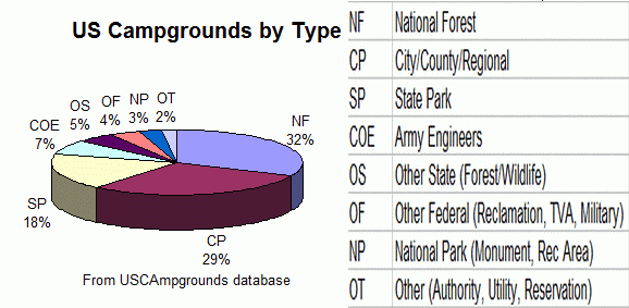
He was always frustrated with campground directories that 1) poorly covered public campgrounds or 2) covered only certain types (eg; National Forest but NOT National Park) and 3) had very poor maps. With the advent of interactive mapping that a hobbyist could use and campground datasets from government and hobbyist sources, it became possible to build a web site that overcame this frustration. Recently it became possible to provide these data and maps on-the-road through laptops, apps, web apps and mobile devices.
Many data sources were used - the majority of the coordinate data was obtained directly from Federal, State and Provincial agencies. Much of the campground descriptive data comes from State/Provincial Park web sites and National Park, BLM and COE web sites. Supplemental coordinate data came from on-line topo maps, Delorme Atlases and from GPS/POI coordinate files developed by individuals and posted on the Internet. There were serious locational errors in all of these sources and so we independently verified the location of all the campgrounds against on-line topo maps.
 Needless to
say, this all took
countless hours of work and dedication
to the goal of a complete, accurate and well-mapped public campground
directory. In spite of our many efforts, we know there are errors still
in the data and we deeply regret any inconvenience these may cause you.
Fortunately things don't change too quickly with campgrounds
because we really don't have a comprehensive way of updating these
data. Please send
us any corrections you find and we will incorporate them.
Needless to
say, this all took
countless hours of work and dedication
to the goal of a complete, accurate and well-mapped public campground
directory. In spite of our many efforts, we know there are errors still
in the data and we deeply regret any inconvenience these may cause you.
Fortunately things don't change too quickly with campgrounds
because we really don't have a comprehensive way of updating these
data. Please send
us any corrections you find and we will incorporate them. We would like to thank the following whose help helped make this compilation and web site possible:
- Adam Schneider, whose GPSVisualizer mapping utilities and whose frequent trechnical assistance has made the mapping portion of this project possible.
- Weatherbase.com which provides access to climate information and historical weather trends.
- Frank Tabor, Gladys, VA, for campground data that made it feasible to get started on this project.
- RVers BEST PUBLIC CAMPGROUNDS By Lee Zabrowski, who provided corrected coordinates for many campgrounds.
- Dow's National Forest Campground Guide which we link to for info about many of our National Forest campgrounds.
- Aaron Hillegass, Executive Director of Kontinua.org , a Free, long-term, self-paced course for future engineers. Aaron kept the site alive for the last decade.
Some of the best existing directories and web sites that include many public campgounds are:
Camping Directories
(on-line and in book form)
Dow's National Forest Campground Guide (on-line and in book form)
Recreation.gov (Reservable Federal sites only)
Reserve America (Reservations for many public campgrounds)
Coleman on-line and book form (for National Forests)
Public Lands Info Center (Western State Campgrounds)
Camping-USA
epgsoft Campground Map
RV Park Reviews
Visit USA
Some Mobile Apps Useful for Campers
CampFone The web app version of this web page (USCAmpgrounds.info) - for all mobile devices
The Ultimate US Public Campgrounds Project - iPhone/iPad app (very extensive public campground coverage)
All Stays Camp & RV (very extensive public and private campgrounds and services)
You Need A Map (great maps, terrain, towns, roads, no internet connection needed, free)
POCKET - Apple and Android App download anything HTML from the web and view it later even with no internet connection